The Geometry Problem
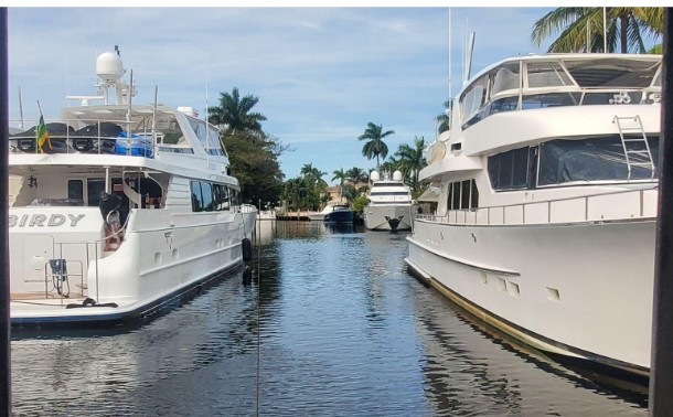
The City of Fort Lauderdale measures dock extension compliance from upland property lines. A property on the north bank may extend 30%(33%) into the channel and comply with City code. A property on the south bank, under Town of Davie jurisdiction, may do the same. Together, they have consumed 60% of the channel width — or more — leaving a functional fairway that is insufficient for a larger vessels and work barges. to maneuver safely.
This is not the fault of any individual property owner. It is a systemic failure of a regulatory framework that was designed around property rights, not navigational physics.
"Planned growth versus geometric failure. Once the channel is functionally narrowed, it is politically and legally difficult to reverse."
Why Multiple Laws Apply
The New River is not governed by one authority. Each layer of regulation creates both constraints and enforcement opportunities.
Federal Law
The Rivers and Harbors Act of 1899 makes unauthorized obstruction of navigable waterways a federal violation. The USCG holds primary authority from the ICW to Marker 12 at Tarpon Bend and governs all bridge operations throughout the river.
33 U.S.C. §403; 33 U.S.C. §409State Law
Florida Statutes §327.44 and §327.70 prohibit vessels and structures from unreasonably restricting safe passage. The State preempts most vessel rules but allows safety-based Boating Restricted Areas (BRAs) when formally documented (§327.46 F.S.). FWC has enforcement authority statewide.
§327.44; §327.46; §327.60; §327.70 F.S.Local Code
City dock code is based on upland property line extensions (30% citywide; 33% annexed areas). Upstream of Marker 12 regulatory authority is shared by the City of Fort Lauderdale, Broward County, SFWMD, and LIWMD. The enforcement gap between Fort Lauderdale and Davie is the critical vulnerability.
ULDR 47-19.6.E; ULDR 47-39.A.1.bFlorida law explicitly prohibits vessels and structures from unreasonably restricting the safe passage of another vessel in a navigable waterway. This statute can be enforced by City Police, FWC and the U.S. Coast Guard under existing authority, without waiting for new corridor designations.